
The Terminal tab displays information about a location within the flight plan, or about any other location that has been selected even if it is not in the plan.
There is a presentation of some common information above a row of tabs.
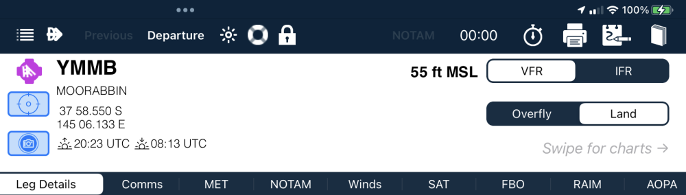
The common information consists of
- A magenta airport symbol shows the published orientation/s and relative lengths (north-up)
- The Location Identifier and Name
- The location Latitude and Longitude
- A rifle scope button to take you directly to the location in the Enroute (maps) pane
- The Beginning (BOD) and End of Daylight (EOD) values (UTC) at the location (for today)
- The location Elevation in feet AMSL
- If the location has a weather camera, a Camera icon will displayed beside the BoD/EOoD.
Weather Cams
Tapping on the Weather Cam icon will access the camera images directly.
Weather cams can also be accessed via the Enroute pane if Weather Cams are turned on in Weather Options, and via a Waypoint Details pop-up window when it has been opened by tapping on a chart.
Weather cams can be zoomed by a standard two finger zooming gesture. When zoomed, the images can be panned with a single finger swiping motion
IFR/VFR
If the location is part of the current flight plan there are buttons to indicate whether the the current leg is to be flown VFR or IFR, and to allow changing from one to the other at that point in the plan.
Land/Overfly/New Stage
There are also buttons to add a planned Landing at the location, or to delete a planned landing and Overfly it. If the location is the last point in a plan the Overfly button changes to a New Stage button, which can be used to copy the location at the end of the plan and start a new stage.
Printing
Any page displayed in the Terminal pane can be printed by simply tapping on the printer icon when the page is open. This includes ERSA, RDS, DAP, Country Airstrip guide pages and SUPS.
Need more help with this?
Help Centre (Tap and hold to open the Link)