
Enabling Pilot Weather Reports displays PIREPs (otherwise known as Pilot REPorts) on the map.
PIREPs are a valuable way of communicating real in-flight observations to other AvPlan EFB users.
A PIREP will be visible for two hours after submission. To read more about submitting a PIREP, refer to Submitting PIREPs.
When the Pilot Weather Reports option is turned on, PIREPs appear on the map in the position they were submitted.

Double-tapping the icon will expand the PIREP to display its full details:
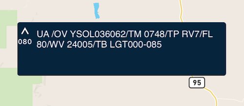
The following required information will be included:
| UA or UUA | used to identify the PIREP as routine (UA) or urgent (UUA) |
|---|---|
| /OV | location of the PIREP |
| /TM | time the PIREP was received from the pilot |
| /FL | flight level or altitude above sea level at the time the PIREP is filed |
| /TP | aircraft type |
optional info to be reported and displayed:
| /SK | sky cover |
|---|---|
| /TA | temperature |
| /WV | wind velocity |
| /TB | turbulence |
| /IC | icing |
| /RM | remarks |
Each PIREP will be accompanied by the following icon:
| Turbulence: | |
| |
Nil turbulence |
| |
Smooth/light turbulence |
| |
Light turbulence |
| |
Light to moderate turbulence |
| |
Moderate turbulence |
| |
Moderate to severe turbulence |
| |
Severe turbulence |
| |
Extreme turbulence |
| Icing: | |
| |
Nil icing |
| |
Trace icing |
| |
Trace to light icing |
| |
Light icing |
| |
Light to moderate icing |
| |
Moderate icing |
| |
Moderate to severe icing |
| |
Severe icing |
To return the PIREP to its compact view, simply double-tap it again.
For further information about how to read PIREPs, visit: www.m0a.com/how-to-read-pireps/
Need more help with this?
Help Centre (Tap and hold to open the Link)