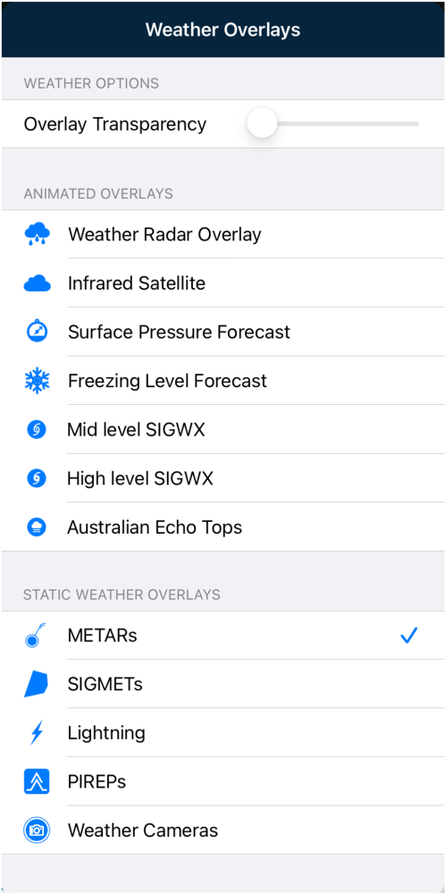
AvPlan EFB can overlay METARs, SIGMETs, PIREPs, Weather Camera Locations and Lightning on the map.
Tap the Weather RADAR icon and select from the five options below the Static Weather Overlays subheading. When METARs are selected, forecasts will automatically refresh in the background when panning around a map.
NOTE: Ceilings Forecast and Visibility Forecast options are only available to Plus/Premium subscribers
Only one Animated Overlay can be active at one time, whereas multiple Static Weather Overlays can be selected at the same time. Once selected, the static overlays selection will be stored and displayed next time AvPlan EFB is launched.
METARs
METAR icons appear with wind indicators at METAR reporting locations. These are colour coded in the following format:
| Green | VFR | Visibility >8km | Cloud >3000ft AGL |
|---|---|---|---|
| Blue | Marginal VFR | Visibility >5km | Cloud >1000ft AGL |
| Yellow | IFR | Visibility >1600m | Cloud >500ft AGL |
| Red | Low IFR | Visibility <1600m | Cloud <500ft AGL |
| Grey | No vis./cloud information |
The wind vector points toward the upwind side of the METAR station. Each full ‘feather’ on the end represents the maximum wind speed (including gusts) rounded to the nearest 10. E.g. 4 ‘feathers’ ≈ 40 knots. Part ‘feathers’ will also display wind rounded to the nearest 5 knots.
METARs coded as SPECI have a red wind direction vector.
METAR icons also appear in the flight log for any places that also have a reporting station as a quick at a glance view of the visual conditions along your route.
 METARs on map/flight plan/nearest items
Tap on a METAR icon to display its full text. See above. Tap on the METAR text row to view the ‘plain English’ translation of the raw text.
SIGMETs/AIRMETs
When selected, any current SIGMETs and/or AIRMETs will display on the map.
 SIGMETs example
Tap a SIGMET Identifier label to view the SIGMET text. While it is selected, the boundaries of that particular SIGMET will change to red. This will help identify it when many SIGMETS are present in the same region.
The SIGMETs are colour-coded for easy identification:
- Severe Turbulence SIGMETs are orange.
- Severe Icing SIGMETs are displayed in blue.
- AIRMETs are coloured purple.
Lightning
When enabled, Lightning displays satellite-sensed lightning strikes worldwide within the last 10 minutes. The overlay updates every few seconds whilst the device is connected to data.
 Global Lightning overlay example
A label in the bottom-left corner of the map displays the age of the last update your app was able to retrieve from the server.

Pilot Weather Reports
For more information about PIREPS, click here.
Weather Cameras
When enabled, camera icons will be visible on the map. Weather camera icons are coloured in the same method as METAR icons where the camera is co-located with a METAR station (see above).
 Weather camera locations
Tap on an icon to view the available images. There may be several cameras in different directions at a single site. Tap the direction options at the top of the image popup to switch between different views.
 Weather camera popup
Tap the Details button to bring up the Waypoint Details menu for that location (if available).
The METAR button is used for quick access to the weather station information (if available).
Need more help with this?
Help Centre (Tap and hold to open the Link)


