
Synthetic Vision brings a whole new level of terrain awareness. Terrain, obstacles and runways ahead of you are depicted in 3D.
With the addition of an external AHRS (Altitude and Heading Reference System) device, pitch and roll are also then accurately depicted.
Synthetic Vision will still work without an AHRS, however no pitch or roll information will be depicted – only the straight-and-level view of the terrain ahead, based on your GPS position. You’ll see the No attitude input warning displayed while operating in this mode.
Synthetic Vision can be shown and hidden at any time by tapping the following icon: 
When turned on, the Synthetic Vision appears on the right half of the map page (one third if the flight plan is also visible).

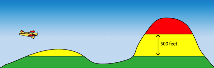
Terrain around you is shaded according to the relative height:
| RED | At your current height or above. |
|---|---|
| YELLOW | 500 feet below, up to your current height. |
| GREEN | More than 500 feet below your current height. |
Charted obstacles and certified runways are also depicted to scale on the landscape:

When straight and level, you can use the Settings button in the lower right-hand corner to zero any or all of the three axes. It’s also a handy shortcut to download the relevant data.
Need more help with this?
Help Centre (Tap and hold to open the Link)