


 Tips
Tips Star your STARs!
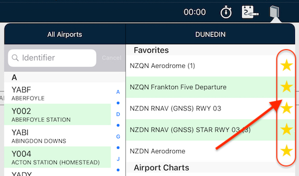
Have you wished you can have particular plates or taxi diagrams handy, regardless of what airport you’re viewing in the […]
Learn More

 Tips
Tips Have you wished you can have particular plates or taxi diagrams handy, regardless of what airport you’re viewing in the […]
Learn More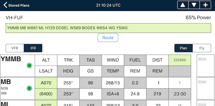 Tips
Tips The interactive electronic flight log has always been one of the core features of AvPlan EFB. An option recently added to […]
Learn More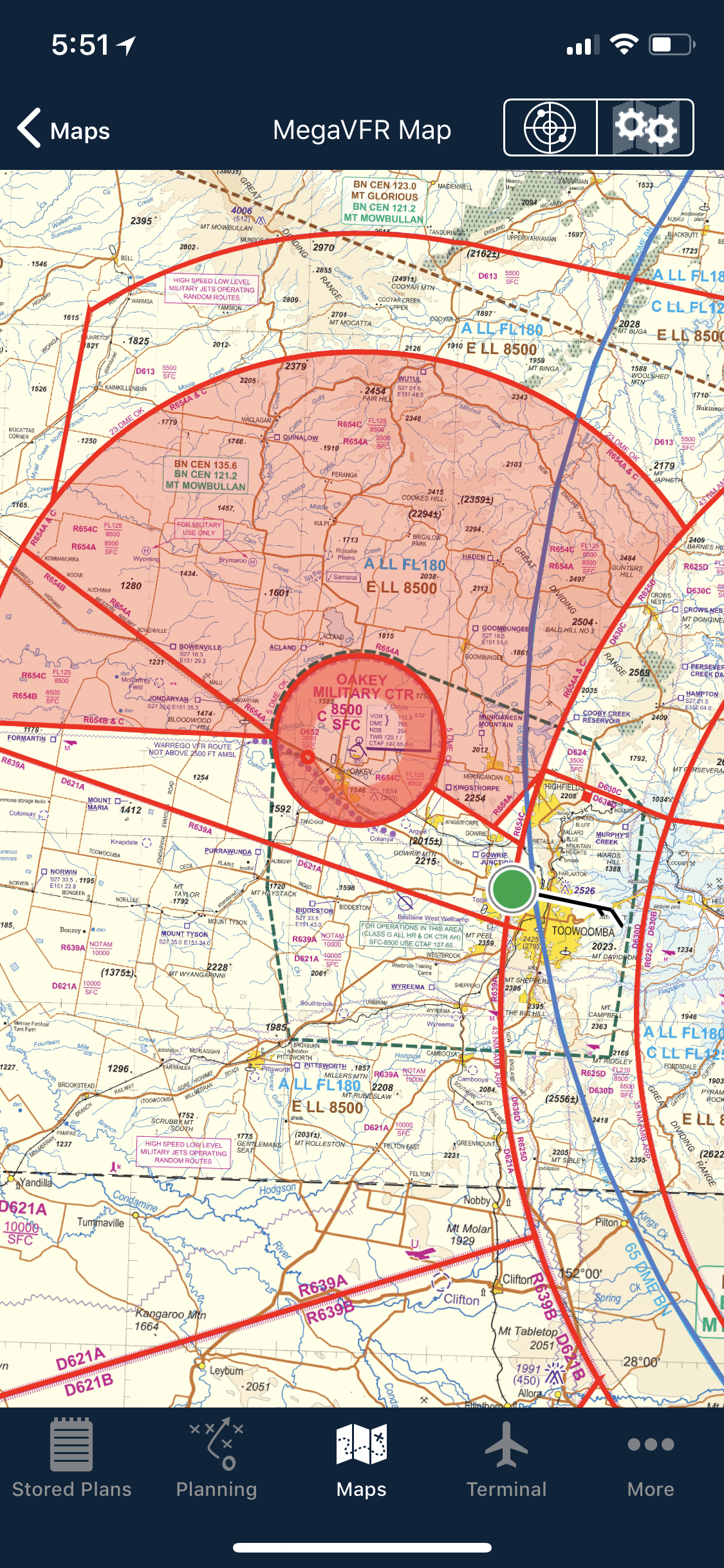 Tips
Tips As well as the usual active airspace regions (military airspace, etc) pilots are used to seeing around their region that have […]
Learn More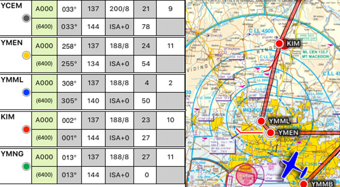 Tips
Tips The METAR Overlay on the EnRoute map has been available in AvPlan EFB for a few years now, however what […]
Learn More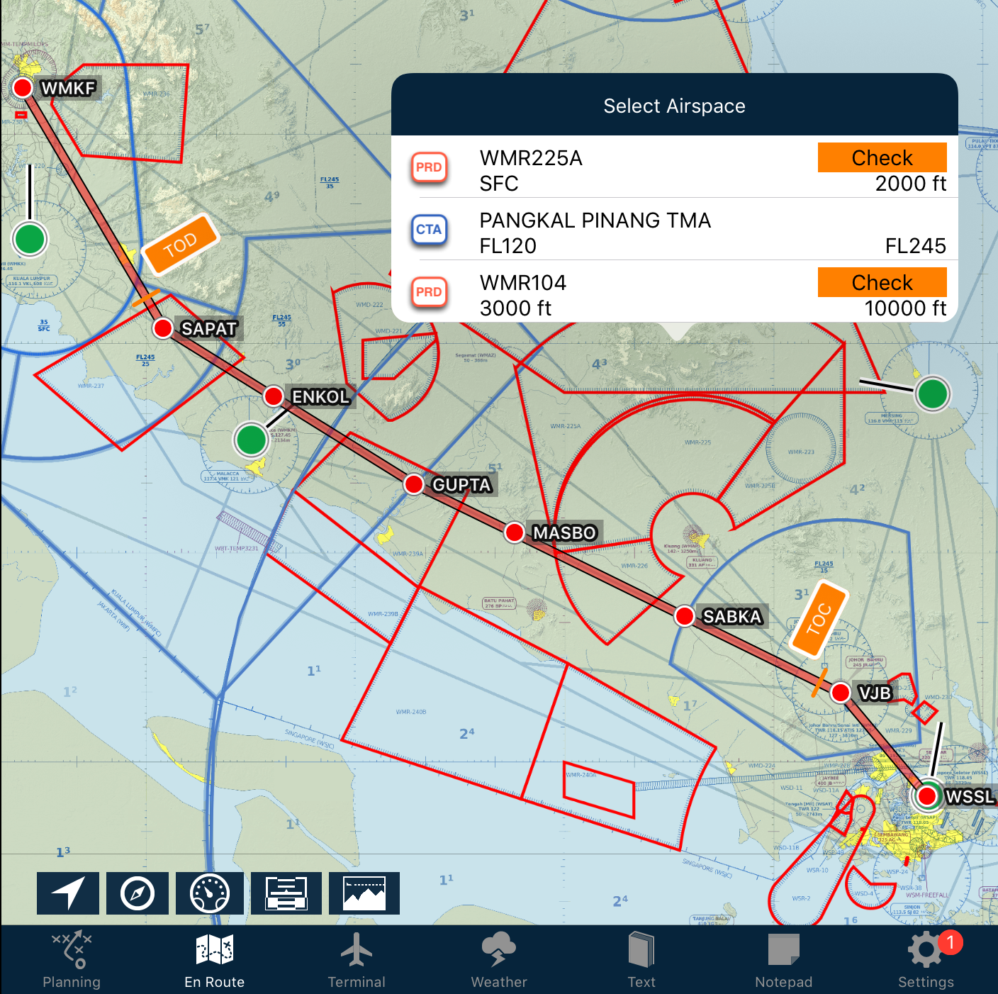 Tips
Tips AvPlan EFB now includes a global database of controlled and special use airspace. No matter where you fly you can […]
Learn More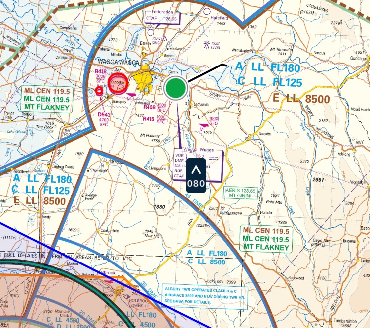 Tips
Tips AvPlan EFB 7.1 brings pilot in-flight reports (PIREPs) to our customers. PIREPs are updated via the internet, ADSB (USA Only) […]
Learn More
The Default Aircraft Icon is the icon that is displayed on the map whenever there is no plan currently open. […]
Learn More
If you simply add a weight to a load station, it’s treated as cargo by AvPlan EFB. If you wish to […]
Learn More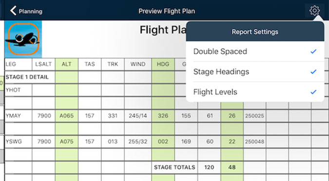
A new feature that appeared in AvPlan EFB version 6 is the ability to control certain aspects of how your printed […]
Learn More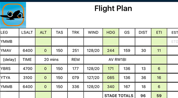
Got some aerial work you wish to do at/around a particular waypoint? Wish to add it to the flight plan […]
Learn More
Last week, I touched upon sharing a particular flight plan with friends or loved-ones. But what if you don’t wish […]
Learn More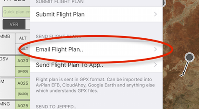
There may be many times that you’d like to share your flight live with others on the ground. They could […]
Learn More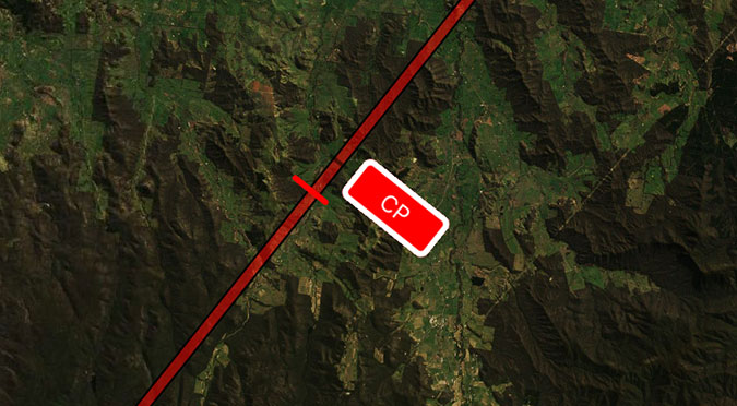
Eagle-eyed PRO Upgrade subscribers may have noticed a new Route Annotation popping up along their flight plan. It’s a little […]
Learn More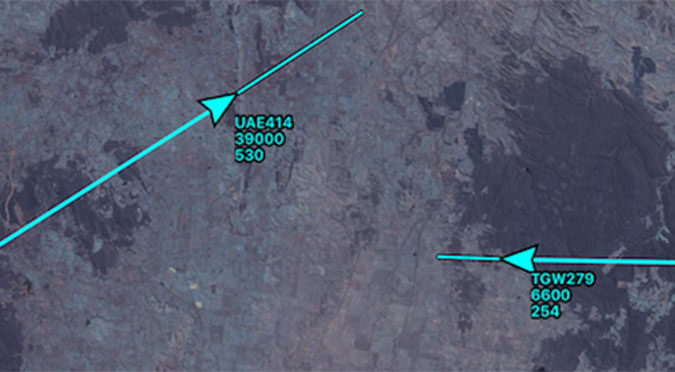
Have you ever been watching traffic on the map and wondered what their next move might be? Now you can […]
Learn More
Most pilots will be used to looking at the Rain RADAR overlay; it’s a great tool, however this does not necessarily […]
Learn More
If you have an aircraft that is flown in a similar loading or setup, you can save time each and […]
Learn More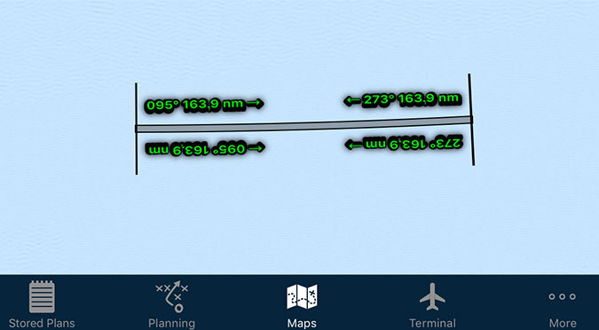
Electronic maps are wonderful things! No more folding, ripping or replacing. However, one thing that is eroded ever so slightly with […]
Learn More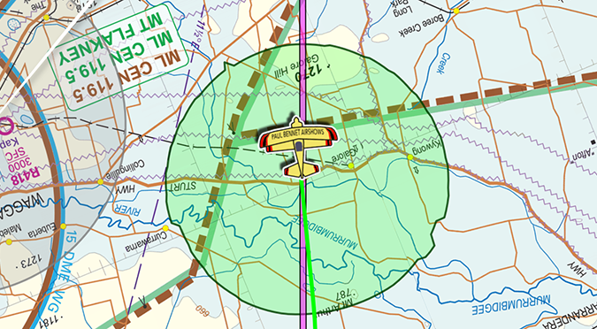
Have you wanted to use the Aircraft Glide envelope, but don’t have the necessary details to get it going? Let’s […]
Learn More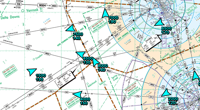
See other AvPlan Live enabled users right on your map – no special equipment needed! AvPlan Live uses your internet connected […]
Learn More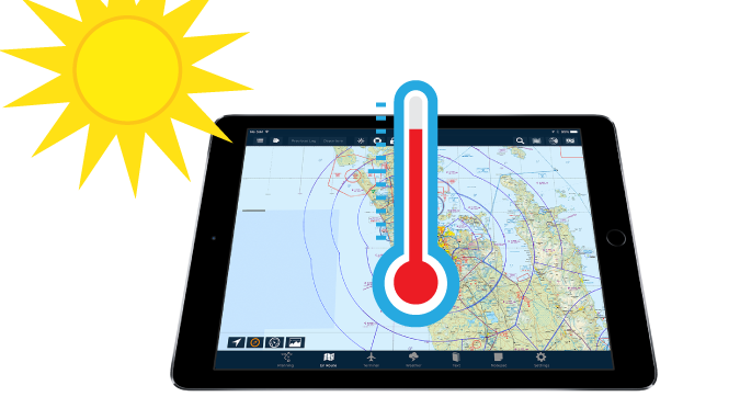
Things are starting to really heat up for those flying down in the Southern Hemisphere. However, it doesn’t just take […]
Learn More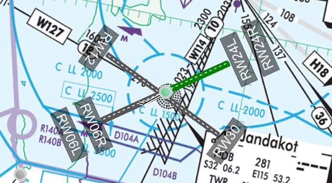
These very handy little lines can be displayed on the map for your planned departure and arrival airports. Turning them on: […]
Learn More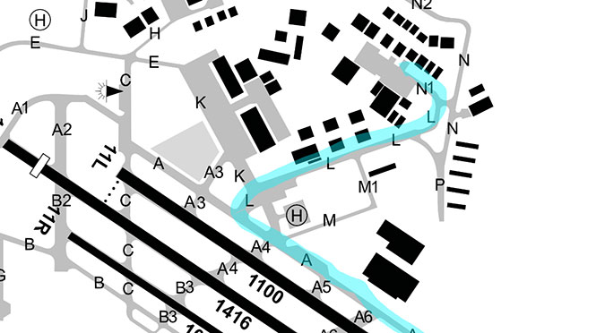
Whether it’s making notes to yourself or highlighting important text, the plate drawing feature in the Terminal pane can come in […]
Learn More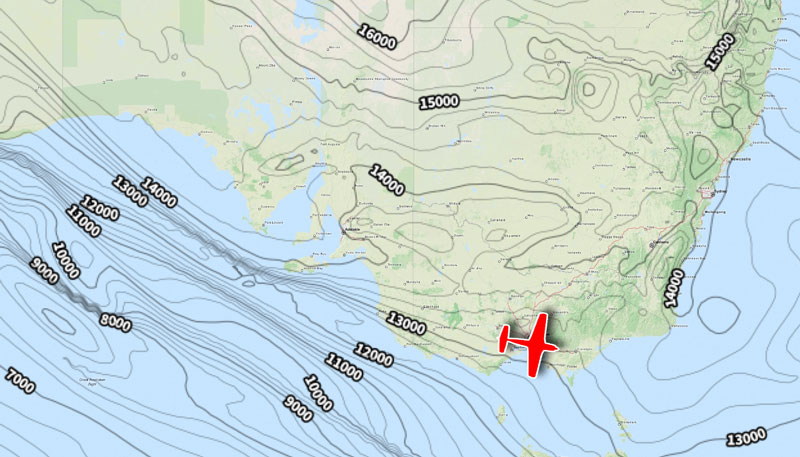
Most pilots (if not all!) will be familiar with the humble Synopic Chart. Where similar points of pressure are joined […]
Learn More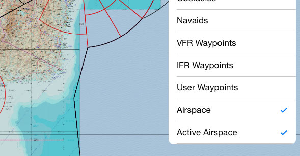
Depending on where you are, aviation maps may give you a lot of information, or they may give you very […]
Learn More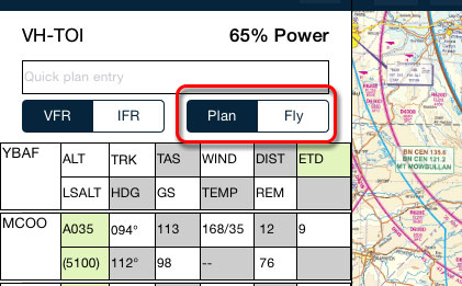
After you’ve prepared your flight plan, it’s time to go fly it. Here’s a typical transition from planning phase to […]
Learn More
How do you track directly towards your distant destination, but still have timing points along your route? You could set […]
Learn More
The course pointer is a favourite feature of mine. At first it took me a moment to understand what it […]
Learn More
What do all those colours mean? The Data Downloads page can give you an at-a-glance window into the data you […]
Learn More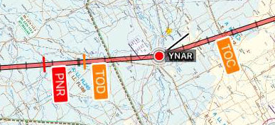
Hi Team, Apologies for missing last week’s tip! My approach to Friday became unstabilised, so I’ve completed a go-around and […]
Learn More
A couple of weeks ago, we looked at the Nearest Items popup. That was a single tap on the map, […]
Learn More
Having an appropriate alternate in your flight plan is an important part of being prepared. Thankfully, AvPlan EFB makes it […]
Learn More
There are many reasons why pilots should be aware of daylight hours – particularly Day VFR pilots. If you’re ever […]
Learn More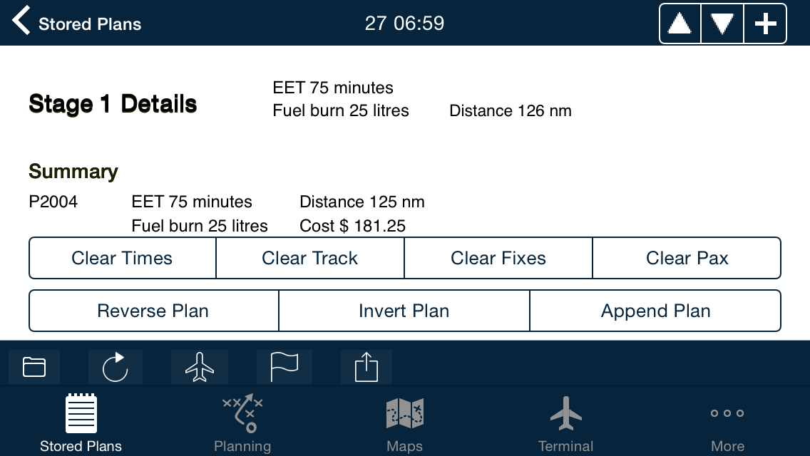
We here at AvPlan EFB headquarters often get asked the question, “How do I re-use a plan that I’ve already […]
Learn More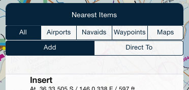
Every AvPlan EFB user has probably tapped on this many hundreds of times (if not thousands!). If you stop and […]
Learn More
Everyone is probably aware of the Direct-To and how it functions on a GPS-enabled device. But what if I told […]
Learn More
Whenever you plan along an air route, the LSALT (Lowest Safe Altitude) for that published route is automatically entered in […]
Learn More
Have you ever had to get to those RNAV-Z plates in the Terminal pane? If you scroll page by page […]
Learn More
It’s that time again – new NavData cycle. NavData is at the core of AvPlan EFB, containing waypoints, airways, navaids, […]
Learn More
Append Plan is a very handy feature of Edit Mode. It allows you to extract waypoints from another plan and have […]
Learn More
METARs are those coloured little circles on the map you may have seen when you first started AvPlan EFB. They are […]
Learn More
AvPlan EFB goes to great lengths to ensure that you don’t forget to cancel your SARTIME. When you submit your […]
Learn More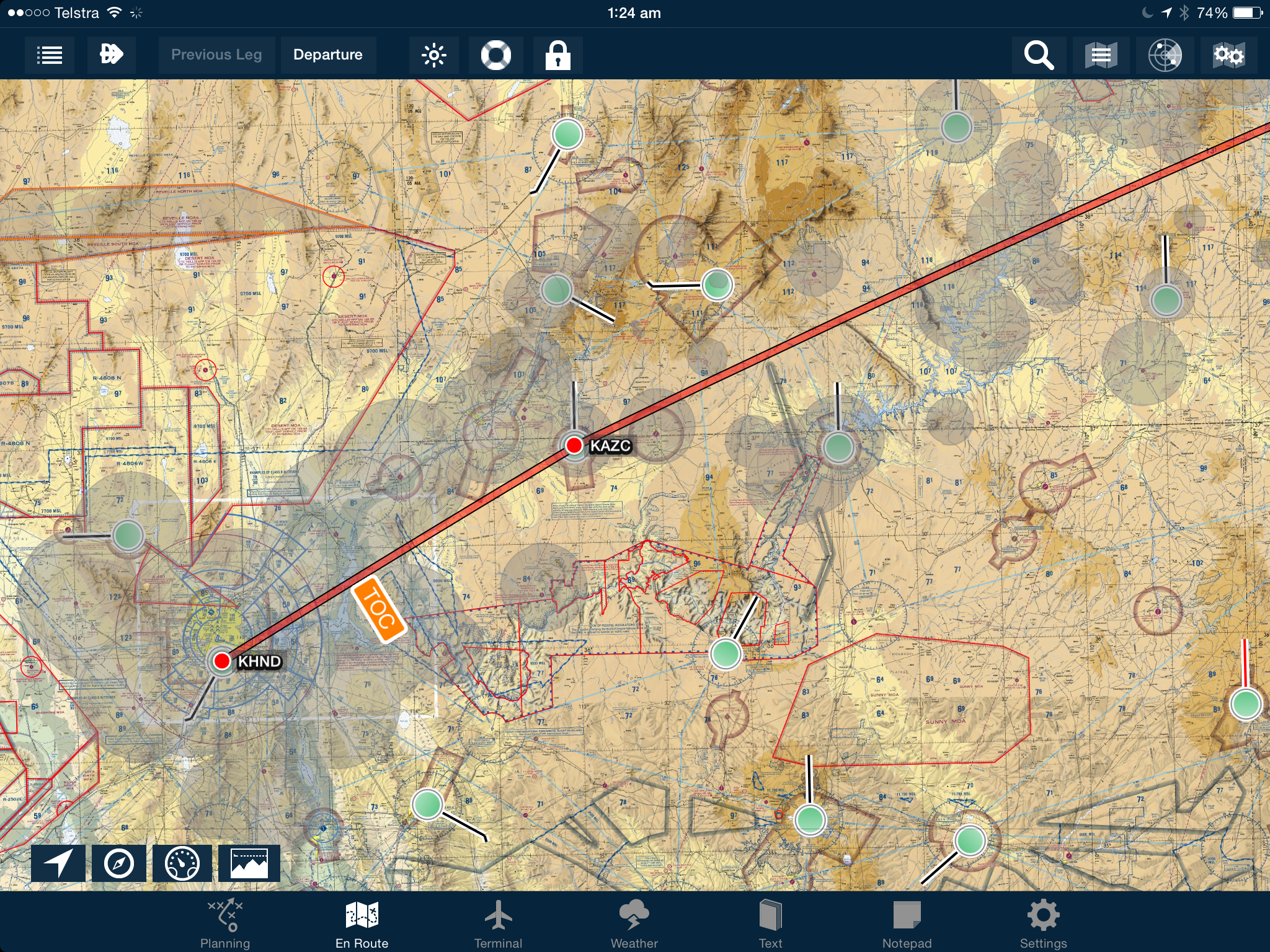
New in AvPlan EFB 5.0 is the ASETPA Glide Calculator. This feature, unavailable anywhere else, shows you during flight planning […]
Learn More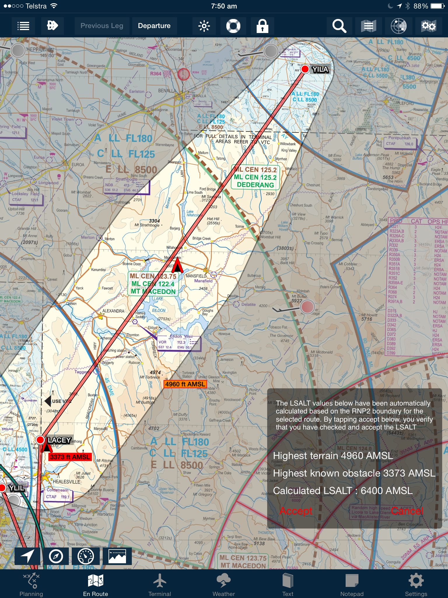
AvPlan EFB 5.0 includes a LSALT calculator to assist you calculating RNP2 based lowest safe altitudes. To display the RNP2 […]
Learn More
Recently, an upgrade in the Australian ATC systems means the use of RMK/GPSRNAV has been deprecated and now is ignored […]
Learn More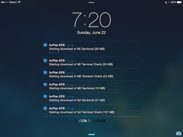
In AvPlan EFB 4.0 we added the ability to to automated data updates. When enabled in Settings, User Settings, Automatic […]
Learn More
Here is a quick video tutorial on how to create and submit a flight plan with AvPlan EFB
Learn More
Around a year ago we transitioned into the new NAIPS environment (when all your NAIPS passwords changed). It appears though, […]
Learn More
A new feature in iOS 7 is ‘AirDrop’. This allows information to be shared across different apps on different devices […]
Learn More
In AvPlan you can now easily visualise a forecast subdivision. Tap Planning, Winds to view the various forecast overview’s for […]
Learn More
Tap the edit button under the flight plan (first of the 5 buttons) to expose two rows of buttons under […]
Learn More
The current and next area frequency can be displayed on the Data Labels (Map Settings, Show Position). If you tap […]
Learn More
AvPlan can now be linked to a dropbox account (or a shared dropbox account for your company documents). Go to […]
Learn More
AvPlan 3.0 and above can display the current status of PRD areas on the map. Tap the map settings button […]
Learn More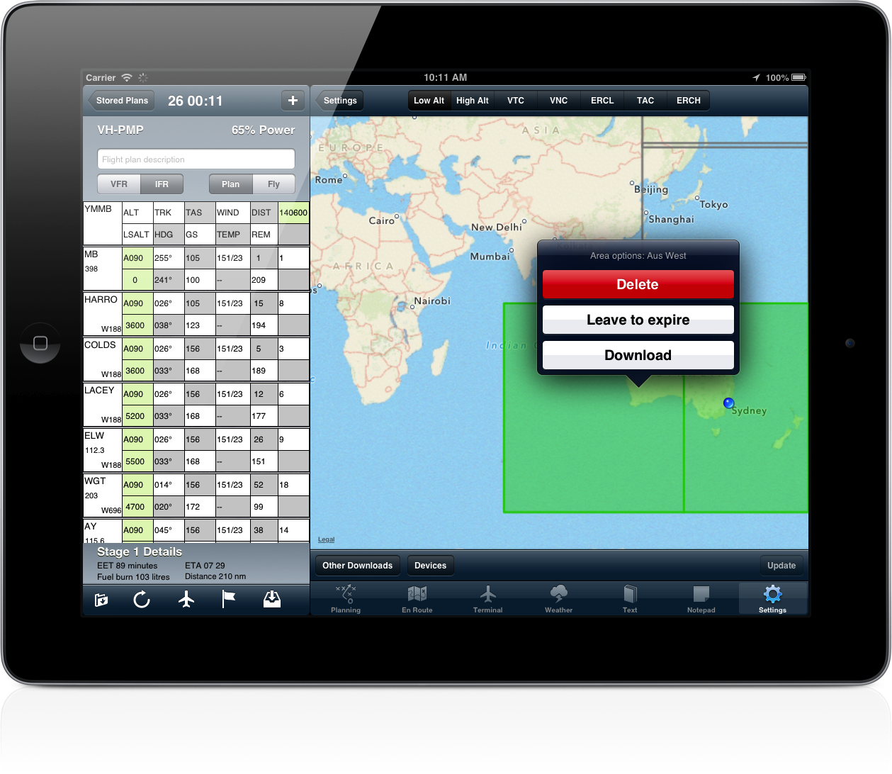
In AvPlan EFB there is a new map-based download page. Different map types can be selected at the top of […]
Learn More
We have added the ability to push a plan via the cloud with the touch of a button. Tap the […]
Learn More
With the latest AvPlan update, when you disable ‘Moving Map Mode’ under Settings, User Settings, the Plan/Fly button enables and […]
Learn More
During flight your iDevice will be subject to many changes in G forces, as you manoeuvre the aircraft. It is […]
Learn More
AvPlan now supports exporting flight plans to your panel mount & newer Garmin GPS units. Tap the send button under […]
Learn More
With the introduction of the ICAO flight plan 2012 changes, there are some additional information required when specifying ‘Z’ or […]
Learn More
If your weight and balance arms are not displaying in the envelope (but the weight calculations look correct) the problem […]
Learn More
The new PRD display on the planning pane displays the various restricted and danger areas that you are going to […]
Learn More
AvPlan supports sharing your flights with others by sending/emailing a link to your flight. Your route and ground track are […]
Learn More
If you have submitted a flight plan as NOSEND and then want to submit it again as a real plan, […]
Learn More
If you have submitted a flight plan and want to reuse it, tap the edit button at the bottom left […]
Learn More
AvPlan 2.0 can show your position on airport diagrams and approach plates. You can individually enable and disable the Aircraft […]
Learn More
There are now two buttons at the bottom left hand side of the map. The left button toggles locking the […]
Learn More
Variable fuel reserves can be enabled or disabled on an aircraft by aircraft basis. Tap the aircraft symbol under the […]
Learn More
To cancel direct-to navigation, activate the appropriate leg in your plan. Tap and hold on the waypoint and a list […]
Learn More
When adding an aircraft, the various avionics may be specified by tapping on ‘Avionics’. If you require to use ‘Z […]
Learn More
To add a flight plan leg to an alternate aerodrome, tap the ‘+’ at the top of the flight plan. […]
Learn More
The red (!) on the icon for the Weather pane indicates there is a SIGMET in the current forecast. […]
Learn More
AvPlan includes the ability to add a fix to a map, just like drawing a circle around your current position […]
Learn More
One method of adding a track point to your plan is tapping the ‘+’ at the top right hand side […]
Learn More
In some cases it can be necessary to delete a single ERSA or DAP page and have it re-download (if […]
Learn More
When a flight plan has been submitted using NOSEND, and then the same plan needs to be sent with a […]
Learn More
Moving map mode is enabled at any time when no flight plan is active. Tapping the map will bring up […]
Learn More
At times you will notice the stored plans have different colours Black – all is in sync Blue – currently […]
Learn More
If you like the app, when a new update appears in the App Store, go and rate the new version. […]
Learn More
To extend your battery life when flight planning, disable the moving map (which will turn off the GPS). Tap ‘Settings’, […]
Learn More
In moving map mode, tapping the data labels that overlay the map will cancel direct-to navigation.
Learn More
An old stored flight plan can be deleted by swiping the row. Tap the delete button which appears and the […]
Learn More
An active SARTIME can be cancelled directly by AvPlan. Firstly, submit a flight plan or SARTIME notification with AvPlan. At […]
Learn More
To enable track up mode on the map, tap the map settings button and tap ‘Map Rotation’. With ‘track up’ […]
Learn More
AvSoft Cloud Services enable flight plans and aircraft details to be backed up and synchronised automatically across your various devices. […]
Learn More
AvPlan includes a terrain database which covers all of Australia at a resolution of approximately 1km square. A view of […]
Learn More
Since version 1.6.1, AvPlan has included an interface to enable it to connect to X-Plane. Tap ‘Settings’, ‘User Settings’ and […]
Learn More
Tips AvPlan can email complete aircraft models, which can be imported by other users on their devices. Tap ‘Settings’, ‘Aircraft Type […]
Learn More
AvPlan now includes the ability to search for a location. Tap the En Route pane to go to a map, […]
Learn More
The table of contents for the AIP is available in AvPlan 1.6.1. Tap ‘Text’ and open a section of the […]
Learn More
To load the AvPlan user manual into iBooks, on your iPad/iPhone, open Safari and open the user manual located at […]
Learn More
The aircraft icon changes colour depending on the state of the GPS signal; Black when location information is unavailable, or […]
Learn More
To delete an unwanted performance profile, tap the aircraft icon under the flight plan, and then the aircraft. Swipe the […]
Learn More
By default, AvPlan will use the last aircraft and flight rules used to create a new flight plan.
Learn More
AvPlan will interpret and display current SIGMET’s as large orange areas on the map. To enable the SIGMET display, on […]
Learn More
Additional fields in a NAIPS plan submission can be entered as follows; DLA/ – tap on the desired leg of […]
Learn More
With ‘Centre on location’ set on the map, you will find you cannot scroll around (zooming will still work). To […]
Learn More
To download an aircraft model from the type database, Go to Settings, Aircraft Type Database in the app on your […]
Learn More
Your iPad and iPhone will shut down if they get too hot. To ensure that your device remains available, do […]
Learn More
If you enter an email address and password into AvPlan (Tap Settings, User Details), the app will automatically backup your […]
Learn MoreHave you wished you can have particular plates or taxi diagrams handy, regardless of what airport you’re viewing in the […]
The interactive electronic flight log has always been one of the core features of AvPlan EFB. An option recently added to […]
As well as the usual active airspace regions (military airspace, etc) pilots are used to seeing around their region that have […]
The METAR Overlay on the EnRoute map has been available in AvPlan EFB for a few years now, however what […]
AvPlan EFB now includes a global database of controlled and special use airspace. No matter where you fly you can […]
AvPlan EFB 7.1 brings pilot in-flight reports (PIREPs) to our customers. PIREPs are updated via the internet, ADSB (USA Only) […]
The Default Aircraft Icon is the icon that is displayed on the map whenever there is no plan currently open. […]
If you simply add a weight to a load station, it’s treated as cargo by AvPlan EFB. If you wish to […]
A new feature that appeared in AvPlan EFB version 6 is the ability to control certain aspects of how your printed […]
Got some aerial work you wish to do at/around a particular waypoint? Wish to add it to the flight plan […]
Last week, I touched upon sharing a particular flight plan with friends or loved-ones. But what if you don’t wish […]
There may be many times that you’d like to share your flight live with others on the ground. They could […]
Eagle-eyed PRO Upgrade subscribers may have noticed a new Route Annotation popping up along their flight plan. It’s a little […]
Have you ever been watching traffic on the map and wondered what their next move might be? Now you can […]
Most pilots will be used to looking at the Rain RADAR overlay; it’s a great tool, however this does not necessarily […]
If you have an aircraft that is flown in a similar loading or setup, you can save time each and […]
Electronic maps are wonderful things! No more folding, ripping or replacing. However, one thing that is eroded ever so slightly with […]
Have you wanted to use the Aircraft Glide envelope, but don’t have the necessary details to get it going? Let’s […]
See other AvPlan Live enabled users right on your map – no special equipment needed! AvPlan Live uses your internet connected […]
Things are starting to really heat up for those flying down in the Southern Hemisphere. However, it doesn’t just take […]
These very handy little lines can be displayed on the map for your planned departure and arrival airports. Turning them on: […]
Whether it’s making notes to yourself or highlighting important text, the plate drawing feature in the Terminal pane can come in […]
Most pilots (if not all!) will be familiar with the humble Synopic Chart. Where similar points of pressure are joined […]
Depending on where you are, aviation maps may give you a lot of information, or they may give you very […]
After you’ve prepared your flight plan, it’s time to go fly it. Here’s a typical transition from planning phase to […]
How do you track directly towards your distant destination, but still have timing points along your route? You could set […]
The course pointer is a favourite feature of mine. At first it took me a moment to understand what it […]
What do all those colours mean? The Data Downloads page can give you an at-a-glance window into the data you […]
Hi Team, Apologies for missing last week’s tip! My approach to Friday became unstabilised, so I’ve completed a go-around and […]
A couple of weeks ago, we looked at the Nearest Items popup. That was a single tap on the map, […]
Having an appropriate alternate in your flight plan is an important part of being prepared. Thankfully, AvPlan EFB makes it […]
There are many reasons why pilots should be aware of daylight hours – particularly Day VFR pilots. If you’re ever […]
We here at AvPlan EFB headquarters often get asked the question, “How do I re-use a plan that I’ve already […]
Every AvPlan EFB user has probably tapped on this many hundreds of times (if not thousands!). If you stop and […]
Everyone is probably aware of the Direct-To and how it functions on a GPS-enabled device. But what if I told […]
Whenever you plan along an air route, the LSALT (Lowest Safe Altitude) for that published route is automatically entered in […]
Have you ever had to get to those RNAV-Z plates in the Terminal pane? If you scroll page by page […]
It’s that time again – new NavData cycle. NavData is at the core of AvPlan EFB, containing waypoints, airways, navaids, […]
Append Plan is a very handy feature of Edit Mode. It allows you to extract waypoints from another plan and have […]
METARs are those coloured little circles on the map you may have seen when you first started AvPlan EFB. They are […]
AvPlan EFB goes to great lengths to ensure that you don’t forget to cancel your SARTIME. When you submit your […]
New in AvPlan EFB 5.0 is the ASETPA Glide Calculator. This feature, unavailable anywhere else, shows you during flight planning […]
AvPlan EFB 5.0 includes a LSALT calculator to assist you calculating RNP2 based lowest safe altitudes. To display the RNP2 […]
Recently, an upgrade in the Australian ATC systems means the use of RMK/GPSRNAV has been deprecated and now is ignored […]
In AvPlan EFB 4.0 we added the ability to to automated data updates. When enabled in Settings, User Settings, Automatic […]
Here is a quick video tutorial on how to create and submit a flight plan with AvPlan EFB
Around a year ago we transitioned into the new NAIPS environment (when all your NAIPS passwords changed). It appears though, […]
A new feature in iOS 7 is ‘AirDrop’. This allows information to be shared across different apps on different devices […]
In AvPlan you can now easily visualise a forecast subdivision. Tap Planning, Winds to view the various forecast overview’s for […]
Tap the edit button under the flight plan (first of the 5 buttons) to expose two rows of buttons under […]
The current and next area frequency can be displayed on the Data Labels (Map Settings, Show Position). If you tap […]
AvPlan can now be linked to a dropbox account (or a shared dropbox account for your company documents). Go to […]
AvPlan 3.0 and above can display the current status of PRD areas on the map. Tap the map settings button […]
In AvPlan EFB there is a new map-based download page. Different map types can be selected at the top of […]
We have added the ability to push a plan via the cloud with the touch of a button. Tap the […]
With the latest AvPlan update, when you disable ‘Moving Map Mode’ under Settings, User Settings, the Plan/Fly button enables and […]
During flight your iDevice will be subject to many changes in G forces, as you manoeuvre the aircraft. It is […]
AvPlan now supports exporting flight plans to your panel mount & newer Garmin GPS units. Tap the send button under […]
With the introduction of the ICAO flight plan 2012 changes, there are some additional information required when specifying ‘Z’ or […]
If your weight and balance arms are not displaying in the envelope (but the weight calculations look correct) the problem […]
The new PRD display on the planning pane displays the various restricted and danger areas that you are going to […]
AvPlan supports sharing your flights with others by sending/emailing a link to your flight. Your route and ground track are […]
If you have submitted a flight plan as NOSEND and then want to submit it again as a real plan, […]
If you have submitted a flight plan and want to reuse it, tap the edit button at the bottom left […]
AvPlan 2.0 can show your position on airport diagrams and approach plates. You can individually enable and disable the Aircraft […]
If you like the app, please rate it in the app store.
There are now two buttons at the bottom left hand side of the map. The left button toggles locking the […]
Variable fuel reserves can be enabled or disabled on an aircraft by aircraft basis. Tap the aircraft symbol under the […]
To cancel direct-to navigation, activate the appropriate leg in your plan. Tap and hold on the waypoint and a list […]
When adding an aircraft, the various avionics may be specified by tapping on ‘Avionics’. If you require to use ‘Z […]
To add a flight plan leg to an alternate aerodrome, tap the ‘+’ at the top of the flight plan. […]
The red (!) on the icon for the Weather pane indicates there is a SIGMET in the current forecast. […]
AvPlan includes the ability to add a fix to a map, just like drawing a circle around your current position […]
One method of adding a track point to your plan is tapping the ‘+’ at the top right hand side […]
In some cases it can be necessary to delete a single ERSA or DAP page and have it re-download (if […]
When a flight plan has been submitted using NOSEND, and then the same plan needs to be sent with a […]
Moving map mode is enabled at any time when no flight plan is active. Tapping the map will bring up […]
At times you will notice the stored plans have different colours Black – all is in sync Blue – currently […]
If you like the app, when a new update appears in the App Store, go and rate the new version. […]
To extend your battery life when flight planning, disable the moving map (which will turn off the GPS). Tap ‘Settings’, […]
In moving map mode, tapping the data labels that overlay the map will cancel direct-to navigation.
An old stored flight plan can be deleted by swiping the row. Tap the delete button which appears and the […]
An active SARTIME can be cancelled directly by AvPlan. Firstly, submit a flight plan or SARTIME notification with AvPlan. At […]
To enable track up mode on the map, tap the map settings button and tap ‘Map Rotation’. With ‘track up’ […]
AvSoft Cloud Services enable flight plans and aircraft details to be backed up and synchronised automatically across your various devices. […]
AvPlan includes a terrain database which covers all of Australia at a resolution of approximately 1km square. A view of […]
Since version 1.6.1, AvPlan has included an interface to enable it to connect to X-Plane. Tap ‘Settings’, ‘User Settings’ and […]
AvPlan can email complete aircraft models, which can be imported by other users on their devices. Tap ‘Settings’, ‘Aircraft Type […]
AvPlan now includes the ability to search for a location. Tap the En Route pane to go to a map, […]
The table of contents for the AIP is available in AvPlan 1.6.1. Tap ‘Text’ and open a section of the […]
To load the AvPlan user manual into iBooks, on your iPad/iPhone, open Safari and open the user manual located at […]
The aircraft icon changes colour depending on the state of the GPS signal; Black when location information is unavailable, or […]
To delete an unwanted performance profile, tap the aircraft icon under the flight plan, and then the aircraft. Swipe the […]
By default, AvPlan will use the last aircraft and flight rules used to create a new flight plan.
AvPlan will interpret and display current SIGMET’s as large orange areas on the map. To enable the SIGMET display, on […]
Additional fields in a NAIPS plan submission can be entered as follows; DLA/ – tap on the desired leg of […]
With ‘Centre on location’ set on the map, you will find you cannot scroll around (zooming will still work). To […]
To download an aircraft model from the type database, Go to Settings, Aircraft Type Database in the app on your […]
Your iPad and iPhone will shut down if they get too hot. To ensure that your device remains available, do […]
If you enter an email address and password into AvPlan (Tap Settings, User Details), the app will automatically backup your […]