


Plan Smarter – Fly Sooner
AvPlan is the leading Australian flight planning application for Apple iOS and Android devices. It is CASA approved under CASR Part 175 so can be a legal replacement for paper maps, ERSA, DAP, AIP and AIP SUP. It is always recommended that a backup be carried in the cockpit, and this backup can be another device running AvPlan EFB, or traditional documentation.
Subscriptions for AvPlan are available for purchase inside the app via the App Store or Google Play, or directly from the website.
AvPlan EFB is designed as the go-anywhere lifetime EFB application that grows with you – from local VFR recreational aviation through to professional IFR charter and regional airline operations. AvPlan has been designed to leverage your investment by using the portability, connectivity, ease of use, reliability and processing capability of your device.
Charts, Data & Diagrams
- Full database of Australian airports, navigation aids, waypoints, visual tracking points and designated IFR routes
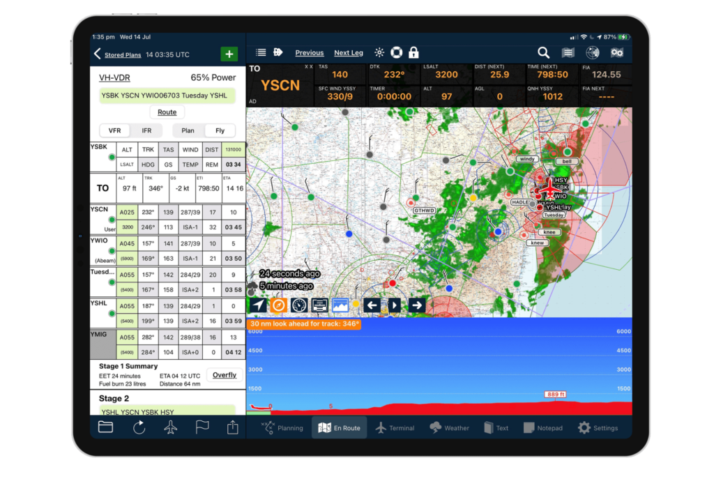
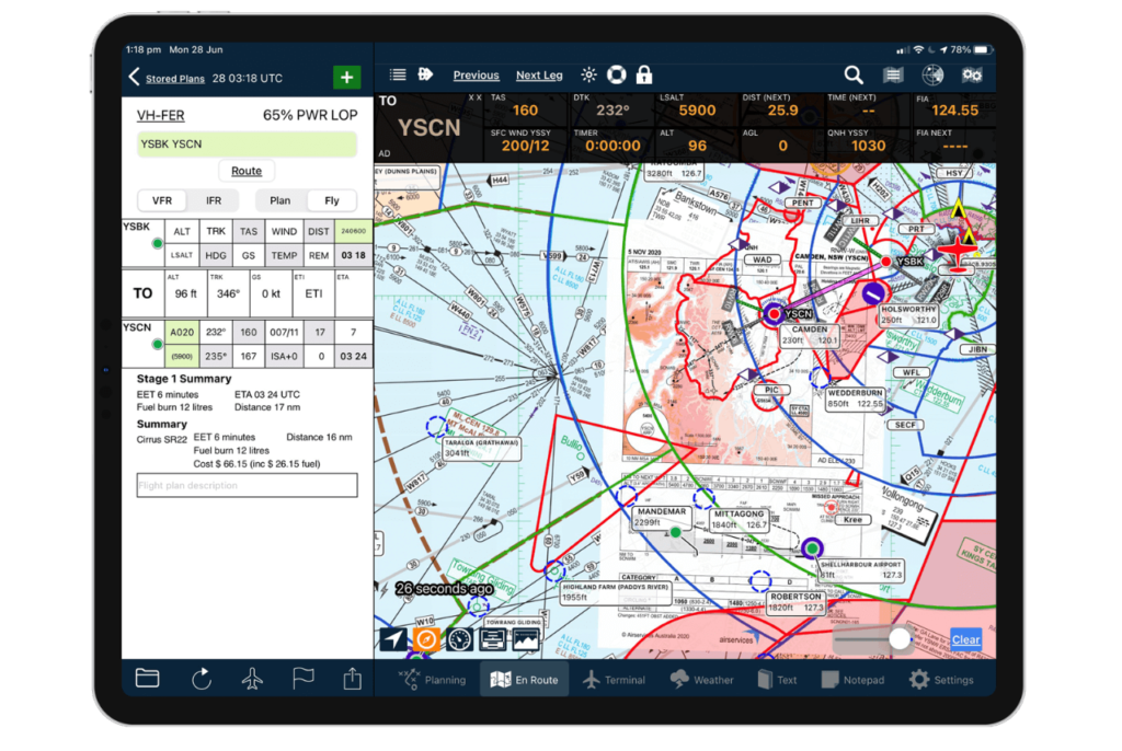
- Built in ERSA, DAP, visual (WAC, VTC, VNC) and IFR (ERC, TAC) charts, approved by CASA as a legal replacement for paper documentation. Our maps automatically adjust to show you exactly what you need to see. No more fumbling for the correct map in flight, or searching for the correct map on your old EFB
- Displays your position on all airport taxi diagrams and instrument approach plates
- Airport taxi diagrams and instrument approach plates can be overlaid all maps
- Point and create user waypoints on visual and IFR charts and approach plates
- Display routing and current position information on visual and IFR charts (including DAP plates)
Automation & Warnings
- NAIPS integration to download and automatically save NOTAMs, forecasts and NAIPS charts.
- NAIPS integration to submit completed flight plans
- Audible warnings to your bluetooth enabled headsets
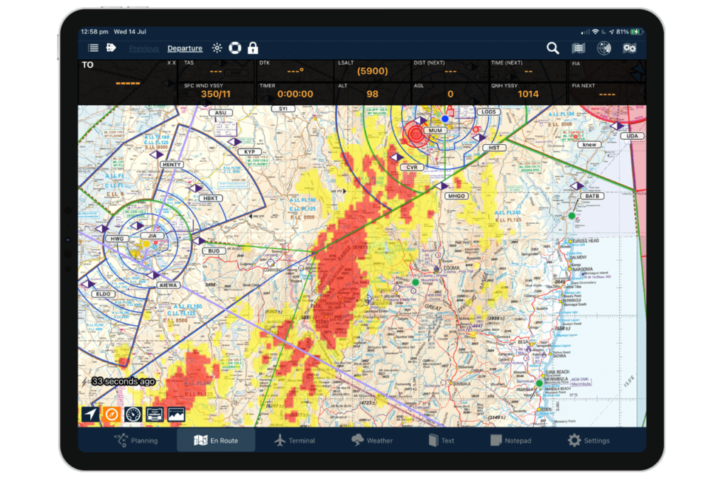
- Terrain warning overlay on all maps
- Terrain warnings and altitude call-outs
- SARTIME warnings
Weather
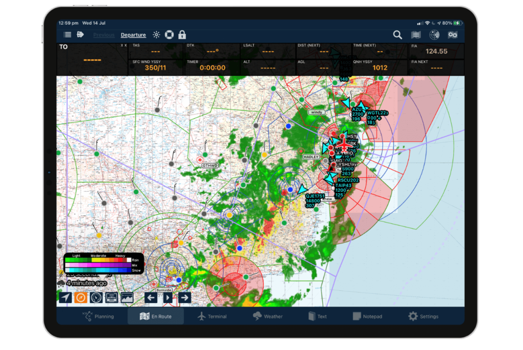
- Access to weather charts (Synoptic, Satellite, BOM weather radar)
- Weather radar overlay on all map types
- Lightning overlay on all map types
- METAR and SIGMET overlays on all maps
Compatible & In-Sync
- Database of aircraft types with detailed performance models
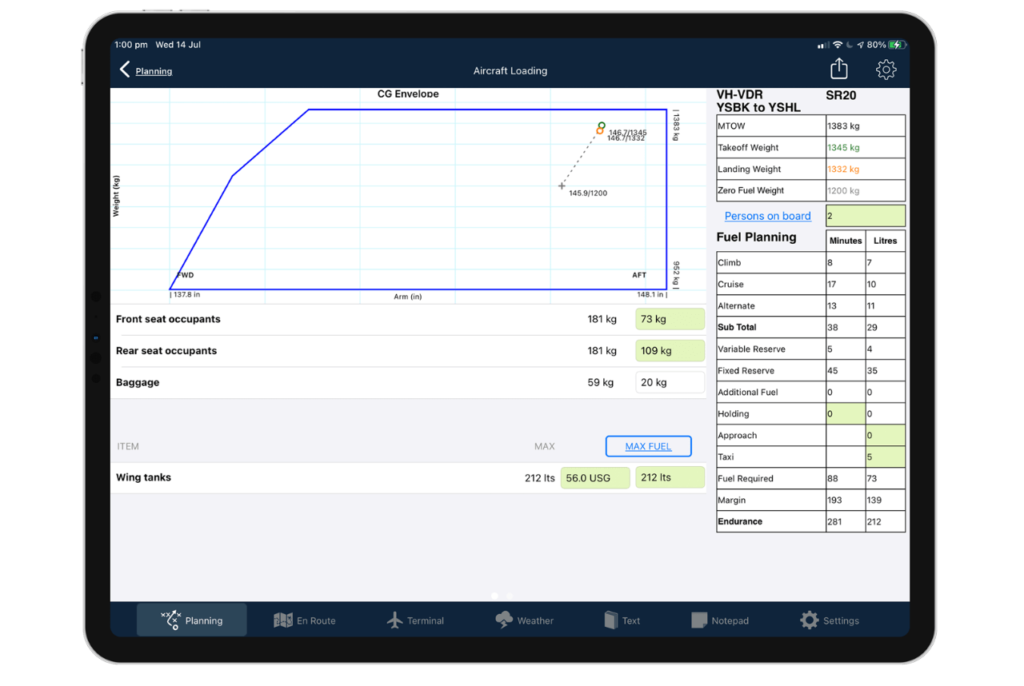
- Weight and balance calculations to suit all aircraft types
- Sophisticated flight plan and aircraft model syncing between your devices
- Import flight plans from Command Flight Planner, Champagne Flight Planner 3000 and Jeppesen FlightStar
- Export flight plans wirelessly to Avidyne IFD-series and Dynon Skyview-series avionics
- Export flight plans to directly to your Garmin Pilot or Jeppesen FliteDeck Pro apps. You can also export via SD card to your handheld Garmin GPS, Garmin G1000
In addition to creating a flight plan, AvPlan EFB can then be used in flight with all the above features to keep track of all in flight planning activities. It acts as a self-updating flight plan, calculating departure times, estimated enroute times and arrival times. AvPlan extends the electronic flight bag concept into something that is in a league of its own.
Maps can be rotated to suit any orientation – just like a paper chart. Fixes can be added in flight, again just like noting down a fix on a paper chart.

AvPlan EFB, a simple, easy to use application for pilots allowing for on the go flight planning and a paperless cockpit.
- Features
- Standard
- Standard Plus
- Premium
- Devices
-
VFR Seamless Mega’ Moving Map
- Android/iOS
-
IFR Seamless Mega Moving Maps
- Android/iOS
-
Flight Planning
- Android/iOS
-
Direct to Navigation
- Android/iOS
-
NAIPS Briefings
- Android/iOS
-
NOTAMS
- Android/iOS
-
Radar & Lighting Overlay
- Android/iOS
-
HUD
- Android/iOS
-
Stopwatch
- Android/iOS
-
Maps Active Airspace, TRA, NOTAMS (MIL LJR ETC)
- Android/iOS
-
Horizontal Terrain Display
- iOS
-
Obstacle Warning
- iOS
-
Social Share Flight Details
- iOS
-
Add Fixes Along Route
- iOS
-
Aircraft Performance Profiles
- Android/iOS
-
Aircraft Weight and Balance
- iOS
-
Fuel Calculations
- Android/iOS
-
User Waypoint
- Android/iOS
-
Automatic Altitude Optimisation
- Android/iOS
-
Sync Flight Plans/Aircraft to Cloud
- Android/iOS
-
Advanced Weather Forecast Overlays (Cloud)
- Android/iOS
-
Print and Send Flight Plan
- Android/iOS
-
GEO REF Airport Diagrams
- Android/iOS
-
Interactive Weather (GAF)
- Android/iOS
-
Weather Forecast Overlays (Sigmet, Airmet)
- Android/iOS
-
PNR, Multiple CP Calculations, Enroute
- iOS
-
Georeferenced Approach Plates
- iOS
-
Import Any Filed Flight
- iOS
Features
-
Standard
-
Standard Plus
-
Premium
-
Devices
Features
VFR Seamless Mega’ Moving Map
Standard
Standard Plus
Premium
IFR Seamless Mega Moving Maps
Standard
Standard Plus
Premium
Flight Planning
Standard
Standard Plus
Premium
Direct to Navigation
Standard
Standard Plus
Premium
NAIPS Briefings
Standard
Standard Plus
Premium
NOTAMS
Standard
Standard Plus
Premium
Radar & Lighting Overlay
Standard
Standard Plus
Premium
HUD
Standard
Standard Plus
Premium
Stopwatch
Standard
Standard Plus
Premium
Maps Active Airspace, TRA, NOTAMS (MIL LJR ETC)
Standard
Standard Plus
Premium
Horizontal Terrain Display
Standard
Standard Plus
Premium
Obstacle Warning
Standard
Standard Plus
Premium
Social Share Flight Details
Standard
Standard Plus
Premium
Add Fixes Along Route
Standard
Standard Plus
Premium
Aircraft Performance Profiles
Standard
Standard Plus
Premium
Aircraft Weight and Balance
Standard
Standard Plus
Premium
Fuel Calculations
Standard
Standard Plus
Premium
User Waypoint
Standard
Standard Plus
Premium
Automatic Altitude Optimisation
Standard
Standard Plus
Premium
Sync Flight Plans/Aircraft to Cloud
Standard
Standard Plus
Premium
Advanced Weather Forecast Overlays (Cloud)
Standard
Standard Plus
Premium
Print and Send Flight Plan
Standard
Standard Plus
Premium
GEO REF Airport Diagrams
Standard
Standard Plus
Premium
Interactive Weather (GAF)
Standard
Standard Plus
Premium
Weather Forecast Overlays (Sigmet, Airmet)
Standard
Standard Plus
Premium
PNR, Multiple CP Calculations, Enroute
Standard
Standard Plus
Premium
Georeferenced Approach Plates
Standard
Standard Plus
Premium
Import Any Filed Flight
Standard
Standard Plus
Premium