


 Tips
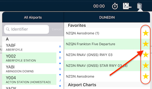
Tips Star your STARs!
Have you wished you can have particular plates or taxi diagrams handy, regardless of what airport you’re viewing in the […]
Learn More

 Tips
Tips Have you wished you can have particular plates or taxi diagrams handy, regardless of what airport you’re viewing in the […]
Learn More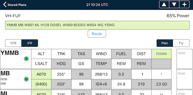 Tips
Tips The interactive electronic flight log has always been one of the core features of AvPlan EFB. An option recently added to […]
Learn More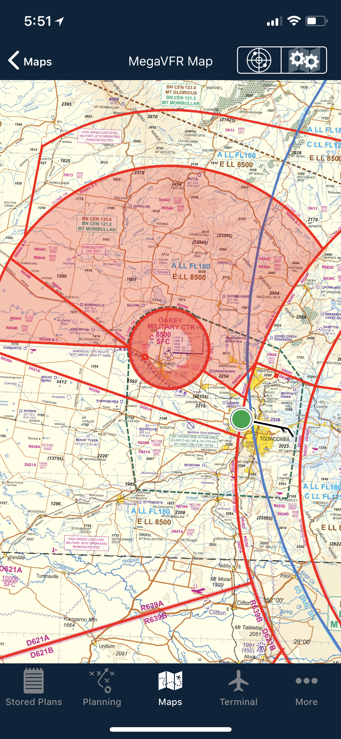 Tips
Tips As well as the usual active airspace regions (military airspace, etc) pilots are used to seeing around their region that have […]
Learn More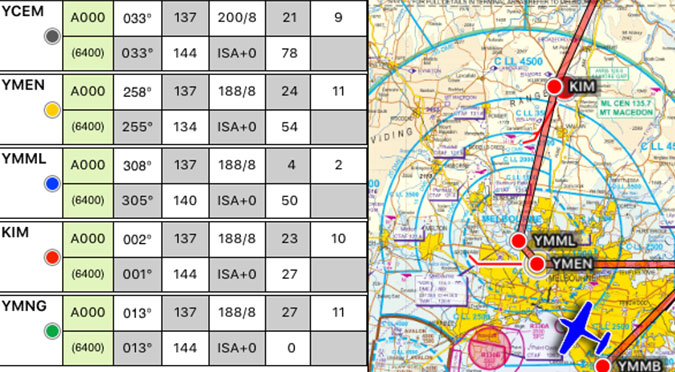 Tips
Tips The METAR Overlay on the EnRoute map has been available in AvPlan EFB for a few years now, however what […]
Learn More
The Default Aircraft Icon is the icon that is displayed on the map whenever there is no plan currently open. […]
Learn More
If you simply add a weight to a load station, it’s treated as cargo by AvPlan EFB. If you wish to […]
Learn More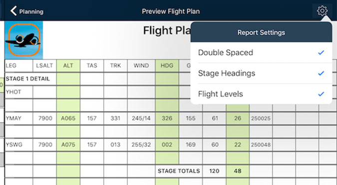
A new feature that appeared in AvPlan EFB version 6 is the ability to control certain aspects of how your printed […]
Learn More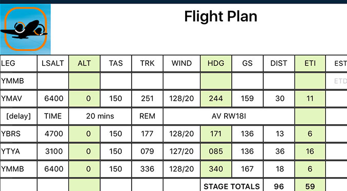
Got some aerial work you wish to do at/around a particular waypoint? Wish to add it to the flight plan […]
Learn More
Last week, I touched upon sharing a particular flight plan with friends or loved-ones. But what if you don’t wish […]
Learn More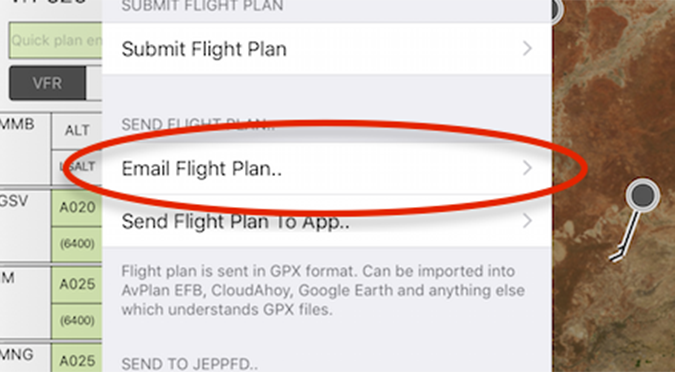
There may be many times that you’d like to share your flight live with others on the ground. They could […]
Learn More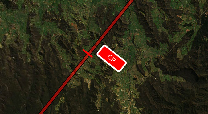
Eagle-eyed PRO Upgrade subscribers may have noticed a new Route Annotation popping up along their flight plan. It’s a little […]
Learn More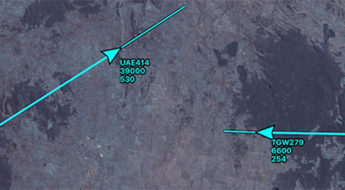
Have you ever been watching traffic on the map and wondered what their next move might be? Now you can […]
Learn More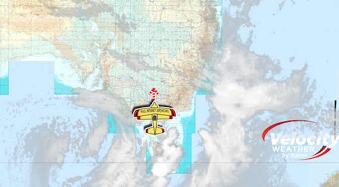
Most pilots will be used to looking at the Rain RADAR overlay; it’s a great tool, however this does not necessarily […]
Learn More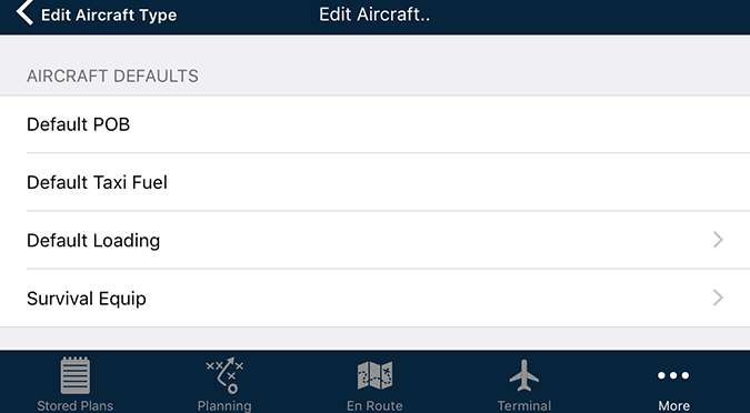
If you have an aircraft that is flown in a similar loading or setup, you can save time each and […]
Learn More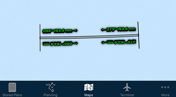
Electronic maps are wonderful things! No more folding, ripping or replacing. However, one thing that is eroded ever so slightly with […]
Learn More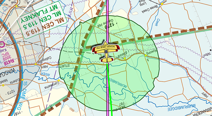
Have you wanted to use the Aircraft Glide envelope, but don’t have the necessary details to get it going? Let’s […]
Learn More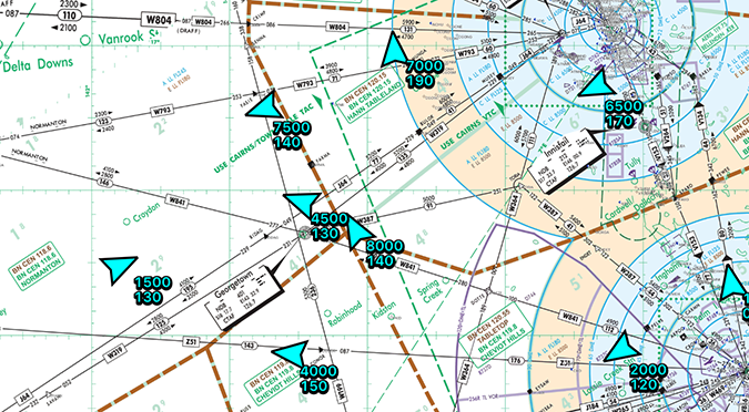
See other AvPlan Live enabled users right on your map – no special equipment needed! AvPlan Live uses your internet connected […]
Learn More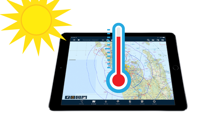
Things are starting to really heat up for those flying down in the Southern Hemisphere. However, it doesn’t just take […]
Learn More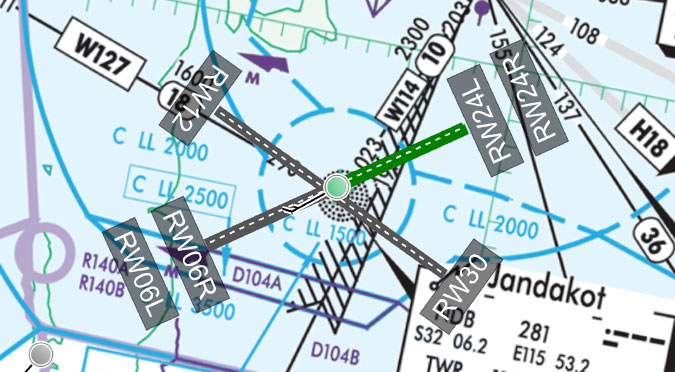
These very handy little lines can be displayed on the map for your planned departure and arrival airports. Turning them on: […]
Learn More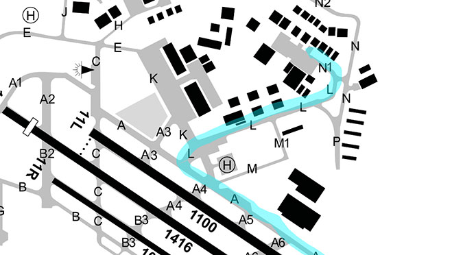
Whether it’s making notes to yourself or highlighting important text, the plate drawing feature in the Terminal pane can come in […]
Learn More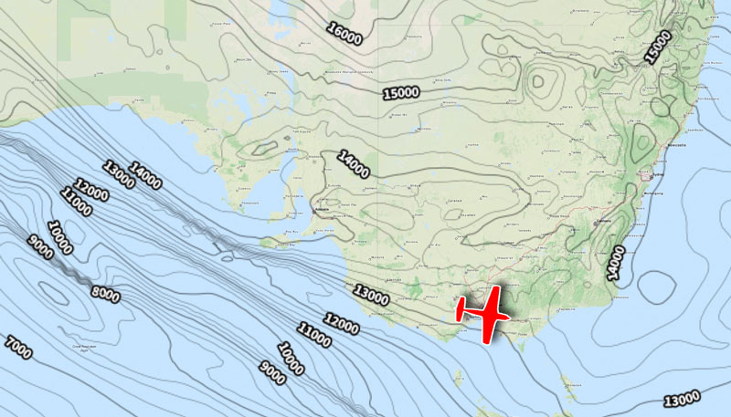
Most pilots (if not all!) will be familiar with the humble Synopic Chart. Where similar points of pressure are joined […]
Learn More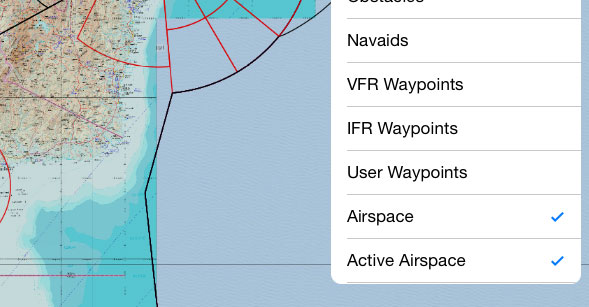
Depending on where you are, aviation maps may give you a lot of information, or they may give you very […]
Learn More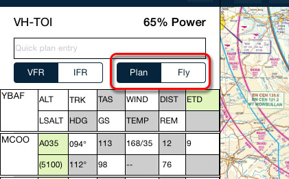
After you’ve prepared your flight plan, it’s time to go fly it. Here’s a typical transition from planning phase to […]
Learn More
How do you track directly towards your distant destination, but still have timing points along your route? You could set […]
Learn More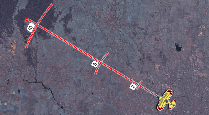
The course pointer is a favourite feature of mine. At first it took me a moment to understand what it […]
Learn More
What do all those colours mean? The Data Downloads page can give you an at-a-glance window into the data you […]
Learn More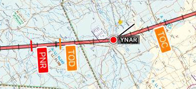
Hi Team, Apologies for missing last week’s tip! My approach to Friday became unstabilised, so I’ve completed a go-around and […]
Learn More
A couple of weeks ago, we looked at the Nearest Items popup. That was a single tap on the map, […]
Learn More
Having an appropriate alternate in your flight plan is an important part of being prepared. Thankfully, AvPlan EFB makes it […]
Learn More
There are many reasons why pilots should be aware of daylight hours – particularly Day VFR pilots. If you’re ever […]
Learn More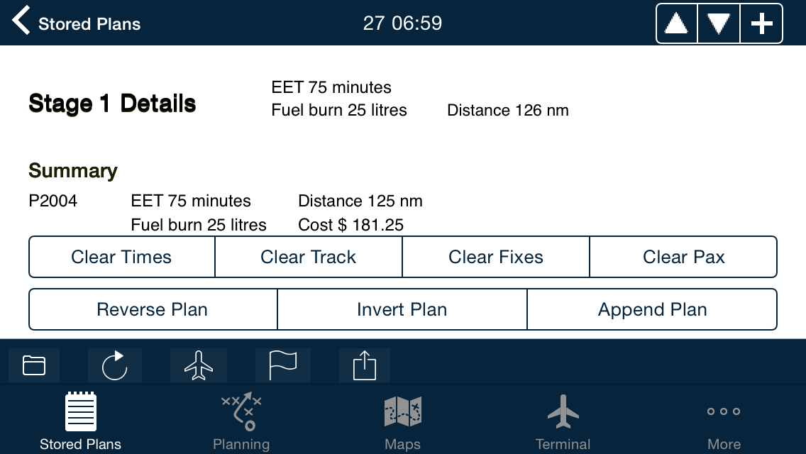
We here at AvPlan EFB headquarters often get asked the question, “How do I re-use a plan that I’ve already […]
Learn More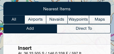
Every AvPlan EFB user has probably tapped on this many hundreds of times (if not thousands!). If you stop and […]
Learn More
Everyone is probably aware of the Direct-To and how it functions on a GPS-enabled device. But what if I told […]
Learn More
Whenever you plan along an air route, the LSALT (Lowest Safe Altitude) for that published route is automatically entered in […]
Learn More
Have you ever had to get to those RNAV-Z plates in the Terminal pane? If you scroll page by page […]
Learn More
It’s that time again – new NavData cycle. NavData is at the core of AvPlan EFB, containing waypoints, airways, navaids, […]
Learn More
Append Plan is a very handy feature of Edit Mode. It allows you to extract waypoints from another plan and have […]
Learn More
METARs are those coloured little circles on the map you may have seen when you first started AvPlan EFB. They are […]
Learn MoreHave you wished you can have particular plates or taxi diagrams handy, regardless of what airport you’re viewing in the […]
The interactive electronic flight log has always been one of the core features of AvPlan EFB. An option recently added to […]
As well as the usual active airspace regions (military airspace, etc) pilots are used to seeing around their region that have […]
The METAR Overlay on the EnRoute map has been available in AvPlan EFB for a few years now, however what […]
The Default Aircraft Icon is the icon that is displayed on the map whenever there is no plan currently open. […]
If you simply add a weight to a load station, it’s treated as cargo by AvPlan EFB. If you wish to […]
A new feature that appeared in AvPlan EFB version 6 is the ability to control certain aspects of how your printed […]
Got some aerial work you wish to do at/around a particular waypoint? Wish to add it to the flight plan […]
Last week, I touched upon sharing a particular flight plan with friends or loved-ones. But what if you don’t wish […]
There may be many times that you’d like to share your flight live with others on the ground. They could […]
Eagle-eyed PRO Upgrade subscribers may have noticed a new Route Annotation popping up along their flight plan. It’s a little […]
Have you ever been watching traffic on the map and wondered what their next move might be? Now you can […]
Most pilots will be used to looking at the Rain RADAR overlay; it’s a great tool, however this does not necessarily […]
If you have an aircraft that is flown in a similar loading or setup, you can save time each and […]
Electronic maps are wonderful things! No more folding, ripping or replacing. However, one thing that is eroded ever so slightly with […]
Have you wanted to use the Aircraft Glide envelope, but don’t have the necessary details to get it going? Let’s […]
See other AvPlan Live enabled users right on your map – no special equipment needed! AvPlan Live uses your internet connected […]
Things are starting to really heat up for those flying down in the Southern Hemisphere. However, it doesn’t just take […]
These very handy little lines can be displayed on the map for your planned departure and arrival airports. Turning them on: […]
Whether it’s making notes to yourself or highlighting important text, the plate drawing feature in the Terminal pane can come in […]
Most pilots (if not all!) will be familiar with the humble Synopic Chart. Where similar points of pressure are joined […]
Depending on where you are, aviation maps may give you a lot of information, or they may give you very […]
After you’ve prepared your flight plan, it’s time to go fly it. Here’s a typical transition from planning phase to […]
How do you track directly towards your distant destination, but still have timing points along your route? You could set […]
The course pointer is a favourite feature of mine. At first it took me a moment to understand what it […]
What do all those colours mean? The Data Downloads page can give you an at-a-glance window into the data you […]
Hi Team, Apologies for missing last week’s tip! My approach to Friday became unstabilised, so I’ve completed a go-around and […]
A couple of weeks ago, we looked at the Nearest Items popup. That was a single tap on the map, […]
Having an appropriate alternate in your flight plan is an important part of being prepared. Thankfully, AvPlan EFB makes it […]
There are many reasons why pilots should be aware of daylight hours – particularly Day VFR pilots. If you’re ever […]
We here at AvPlan EFB headquarters often get asked the question, “How do I re-use a plan that I’ve already […]
Every AvPlan EFB user has probably tapped on this many hundreds of times (if not thousands!). If you stop and […]
Everyone is probably aware of the Direct-To and how it functions on a GPS-enabled device. But what if I told […]
Whenever you plan along an air route, the LSALT (Lowest Safe Altitude) for that published route is automatically entered in […]
Have you ever had to get to those RNAV-Z plates in the Terminal pane? If you scroll page by page […]
It’s that time again – new NavData cycle. NavData is at the core of AvPlan EFB, containing waypoints, airways, navaids, […]
Append Plan is a very handy feature of Edit Mode. It allows you to extract waypoints from another plan and have […]
METARs are those coloured little circles on the map you may have seen when you first started AvPlan EFB. They are […]